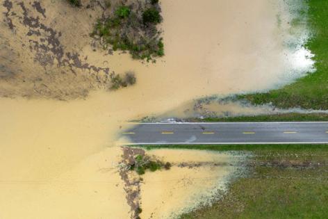
Why is it raining so much in Kentucky? A rare rain-soaked 'conveyor belt' is crashing into a stingy front
Published in News & Features
LEXINGTON, Ky. — You’re not the only one asking this question: Why is it raining so darn much?
Some of Kentucky’s foremost and longest-tenured experts on weather and flooding aren’t sure when they last saw a system so sustained hang over the state.
From Thursday afternoon through Saturday, downpours have pelted much of the commonwealth. And it’s expected to continue into Sunday, particularly in western parts of Kentucky.
The story of high-profile flooding events over the past few years — from this February’s statewide deluge to 2022’s disastrous flood in eastern Kentucky — has largely been one of bursts of rain over a short period of time.
So what’s making the event this week so prolonged?
The biggest factor is what’s called a stationary front.
Perhaps better known as the alternating red and blue squiggly line seen on the radar maps of meteorological broadcasts, a stationary front forms when cold and warm fronts meet and neither budges. It is the hallmark of a long rainy period, according to the National Weather Service.
The stationary front in this case is marching from southwest to northeast and is draped along the length of the state. It’s been even more “stationary” than such fronts normally are because of an intense, warm area of high pressure to the southeast that’s prevented the front from moving through Kentucky.
Paducah-based National Weather Service meteorologist Sean Poulos described the high-pressure area as a “ridge” holding the stationary front in place.
“That ridge is so strong that (the storms) just kind of keep hitting a wall and get shifted back to the north. Then you’ve got these waves of energy that come in from the west, from the plains, that just keep sparking, igniting additional rounds of storms,” Poulos said.
Forecasters also are looking south and the moisture churning from a warm Gulf of Mexico. WKYT Chief Meteorologist Chris Bailey told the Herald-Leader it’s been a key ingredient of charging the rains, with “repeat thunderstorms” scraping over the same areas.
“The front is just hanging there, and all it needs is any bit of moisture coming from the Gulf. All this deep tropical moisture is coming northward into that, and it’s interacting with that front,” Bailey explained.
“And the amount of available moisture that is out there in the atmosphere is way above normal. So now, any normal shower thunderstorm that goes up just has the capabilities of producing inordinate amounts of rain, and it’s over the same areas, so you’re getting repeat thunderstorms moving through one right after another.
“It’s just like a conveyor belt of storms and moisture coming up the Mississippi Valley and then taking a hard right across Kentucky. And (the stationary front) really just hasn’t moved at all since it moved in here Wednesday night, and it won’t move until we get into later Sunday and Sunday night,” Bailey said.
While the “extra stationary” stationary front and the buckets of moisture moving in from the Gulf are the primary reasons for the sustained rains, Chris Barton, a professor and hydrologist at the University of Kentucky mentioned the possibility of climate change as a contributor.
Barton closely studies flooding and monitors a weather station in Eastern Kentucky. He said that moisture coming from places that have been abnormally warm and unloading on Kentucky and other parts of the Midwest and Upper South has been a pattern for all the recent major flooding events.
That includes this system, the floods this February and 2022’s historic flood.
“A lot of the other events that we’ve had that have caused flooding were sort of attributed to a warming of the atmosphere. These storms that we’ve been having, like this one, we used to see every couple of decades. Now it’s practically every six months,” Barton said.
Make no mistake, he said: “There’s something happening with the weather.”
The result has been a massive, almost unprecedented amount of rain. Bailey said portions of Kentucky will get a whole season’s worth of rain over this four-day period.
“Parts of Western Kentucky are right at 10 inches. Here in Lexington, we’re near 6 inches of rain already,” Bailey said Friday evening. “For perspective’s sake, 10 to 15 inches is what you would expect in the entire summer.”
Barton said Saturday will be a “tipping point” for parts of the commonwealth, as the soils are already saturated. He said the place to look for flooding impacts is existing streams and rivers, as opposed to headwaters or ephemeral streams, which cause more trouble during concentrated rainfall over a short time, like the eastern Kentucky floods of 2022.
“The problem we’re getting into right now is that the soil is completely saturated,” Barton said. “There’s nowhere for the water to go aside from the streams and rivers.”
©2025 Lexington Herald-Leader. Visit kentucky.com. Distributed by Tribune Content Agency, LLC.


Comments