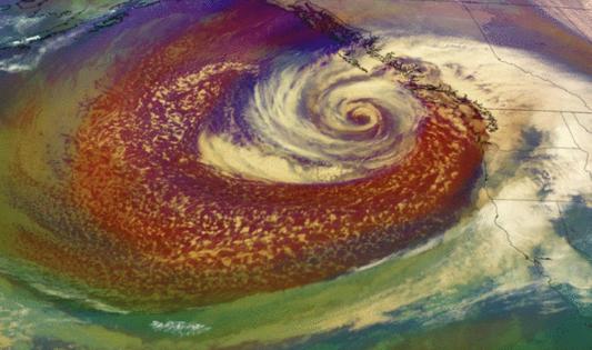
California bomb cyclone storm: When will rains hit LA area and how bad will it be?
Published in News & Features
LOS ANGELES — Northern California is being drenched by the first major atmospheric river storm of the season, with rain totals reaching well over 7 inches in many areas, and continued rain on Thursday stretching the threat for flooding and mudslides.
The slow-moving storm was strengthened by a so-called bomb cyclone, which describes how rapidly the system intensified in the Pacific before it moved ashore. By Friday, the rain will begin moving southward, and while forecasters are saying some rain is likely to hit Southern California by the weekend, it will be dramatically less than than what's been seen north of the Bay Area this week.
Here is what we know:
Forecast
In Southern California, the chances for rain have been steadily increasing as the system advances, with forecasters now confident that the region could see measurable amounts beginning this weekend and into early next week.
Friday evening : Rain begins across the Central Coast.
Saturday: Light rains hit Los Angeles and Ventura counties in the morning and likely linger through the evening.
Next week: A second system is expected to bring the chance for rain again on Sunday, possibly through Wednesday, but the exact forecast remains in flux.
Conditions
On Saturday, Los Angeles and Ventura counties could see anywhere from a tenth to a third of an inch of rain. San Luis Obispo and Santa Barbara counties could see up to an inch in some areas.
A second round of rain expected to begin Sunday could be "a little stronger than the first but still likely in the 'beneficial rain' category," the National Weather Service said in its latest L.A. forecast. There are low chances of any significant issues like flooding in Southern California, forecasters said, though roads could be slick and snarl traffic.
Fire risk
The storm comes just two weeks after the Mountain fire destroyed or damaged more than 350 homes in Ventura County. That fire was fueled by dry conditions and intense Santa Ana winds.
"We're thinking it's going to be more of a beneficial rain," said Bryan Lewis, a National Weather Service meteorologist in Oxnard. He noted this weekend's rain could help ease some fire concerns, but likely will not eliminate those worries entirely.
Longer-term trends
Through at least the end of the month, the National Weather Service's Climate Prediction Center is forecasting an increased chance for above-average rainfall across much of California, but predictions stretching into mid-December become less clear.
The latest three-month outlook through February, issued Thursday, still shows an equal chance for precipitation either above or below average across much of California — making it uncertain if the state could see a third consecutive exceptionally wet winter.
Matt Rosencrans, a meteorologist with the National Oceanic and Atmospheric Administration's Climate Prediction Center, said this first major atmospheric river doesn't necessarily indicate anything about what to expect the rest of the rainy season.
It simply signals that "we have entered the rainy season for much of the western [U.S.], but a single event does not have much relation to the pattern in the next three to four months," Rosencrans said.
"Atmospheric rivers and the storms that bring them are typical for the Pacific Northwest and California during the winter, and, as such, we expect some of them this winter," he said. "However, there is considerable uncertainty surrounding how many and how intense these storms may be."
©2024 Los Angeles Times. Visit at latimes.com. Distributed by Tribune Content Agency, LLC.


Comments